 |
|
| Serving Copiah, Hinds, Madison, Rankin, Simpson, Warren, and Yazoo Counties... |
|
|
 |
|
Geographic Information System (GIS)
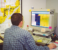 CMPDD's Geographic Information System is a computer-based technology that is used for viewing and manipulating any kind of data that can be referenced geographically. This technology
gives District planners and outside researchers the ability to analyze and visually display a host of geographically referenced information very effectively. The powerful database
management and display features of GIS software allow complex combinations of scientific data to be merged into easily enterpretable maps and graphics.
CMPDD's Geographic Information System is a computer-based technology that is used for viewing and manipulating any kind of data that can be referenced geographically. This technology
gives District planners and outside researchers the ability to analyze and visually display a host of geographically referenced information very effectively. The powerful database
management and display features of GIS software allow complex combinations of scientific data to be merged into easily enterpretable maps and graphics.
Please contact Chuck Carr for more information at: ccarr@cmpdd.org.
Revised: March, 2006
|
DEPARTMENTS
-
-
-
-
-
-
-
-
- |
-
-
|
|
|
|
|
|
|
|
|